
 Facebook
 X
X
 Pinterest
 Copy Link
The Blue Ridge Parkway: A Local Guide for Western North Carolina
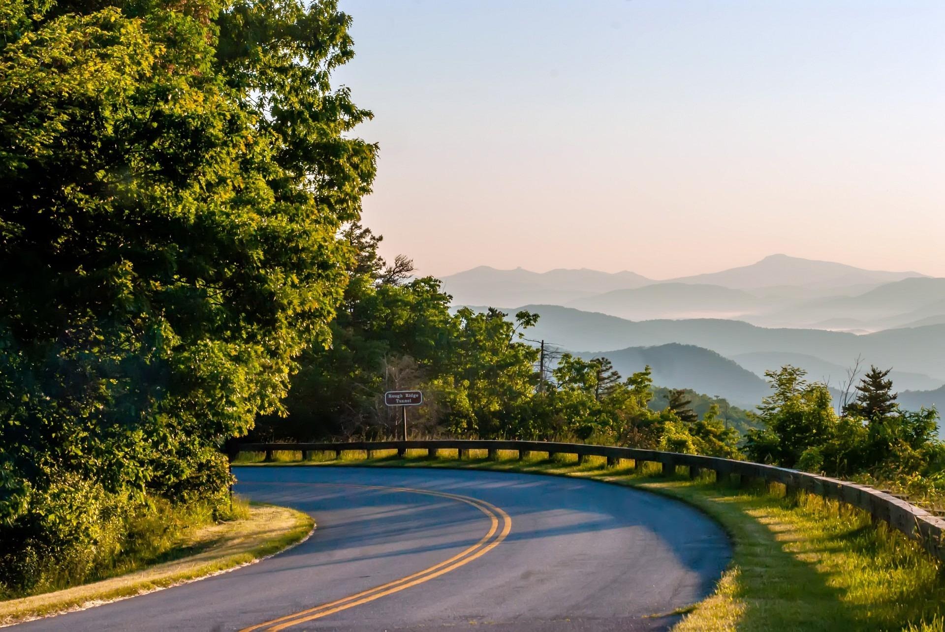
In Western North Carolina, you rarely hear someone say “Blue Ridge Parkway.”
Locals simply say:
“Let’s take the Parkway.”
For visitors, that shorthand can be confusing. The Blue Ridge Parkway is a 469-mile scenic roadway managed by the National Park Service, stretching from Shenandoah National Park in Virginia to Great Smoky Mountains National Park in North Carolina.
But it’s more than a road.
It is one of the most ambitious landscape preservation projects in American history — and one of the defining geographic features of life in the mountains.
A Road Born in the Great Depression
The Blue Ridge Parkway was authorized in 1936 as part of Franklin D. Roosevelt’s New Deal.
Its goals were clear:
- Create jobs through the Civilian Conservation Corps (CCC)
- Connect Shenandoah National Park to Great Smoky Mountains National Park
- Stimulate tourism in struggling Appalachian communities
- Preserve scenic ridgelines before development overtook them
Thousands of CCC workers lived in mountain camps and built large portions of the roadway by hand. Many of the stone bridges, guard walls, culverts, and overlooks you see today were constructed with locally quarried rock in the late 1930s and 1940s.
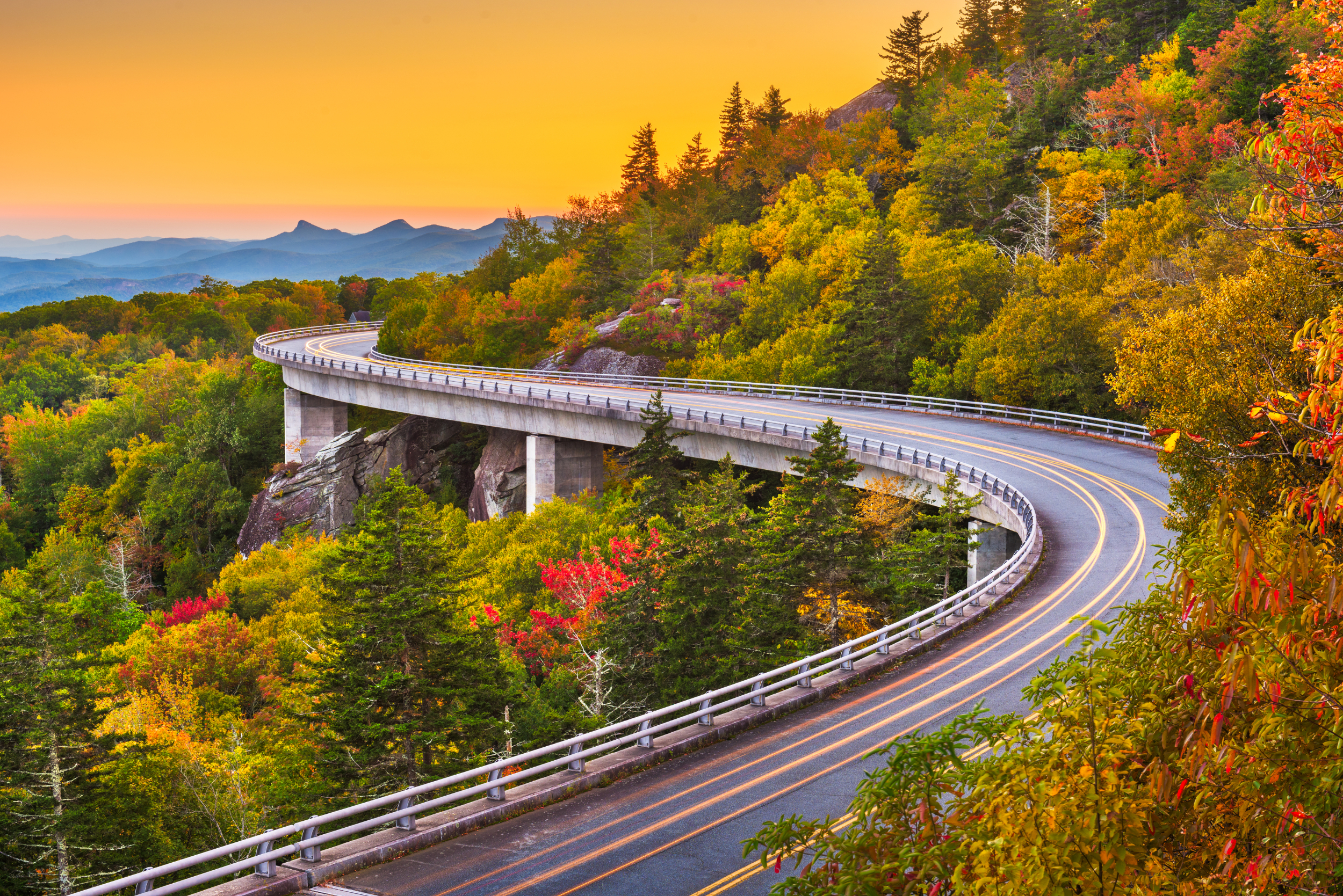
Although construction began in the 1930s, the Parkway was not fully completed until 1987, when the Linn Cove Viaduct near Grandfather Mountain was finished. That elevated bridge was engineered to “float” around fragile terrain rather than blasting through it — a major environmental milestone in roadway design.
Today, the Parkway is one of the most visited units in the National Park Service system.
National Park Connections
The Blue Ridge Parkway is not itself a national park — it is a separate unit of the National Park Service.
It connects:
- Shenandoah National Park (Virginia)
- Great Smoky Mountains National Park (North Carolina/Tennessee)
It begins at Rockfish Gap in Virginia and ends near Cherokee, North Carolina at the boundary of Great Smoky Mountains National Park.
It does not cut through other national parks. Instead, it functions as a protected scenic corridor linking them.
Geography, Elevation & Mileposts
The Parkway runs 469 miles along the crest of the Appalachian Highlands.
Mileposts increase from north (Virginia) to south (North Carolina). Every overlook, trailhead, and landmark is referenced by mile marker — locals navigate by milepost numbers.
In the Haywood County region:
- Valley elevations sit around 2,700–3,000 feet
- Parkway elevations often exceed 5,000 feet
- The highest point on the entire Parkway is Richland Balsam (Milepost 431) at 6,053 feet
Elevation shapes everything:
- Temperatures are often 10–15 degrees cooler than in town
- High-elevation spruce-fir forests appear
- Fall color timing shifts by weeks
- Snow and ice can close sections even when valleys are clear
You can gain thousands of feet in elevation in under 30 minutes.
Access Points Near Haywood County
For residents and visitors in Haywood County, Parkway access is convenient and varied.
Common entry points include:
Maggie Valley Area
- Soco Gap (US 19)
- Waterrock Knob entrance
Waynesville Area
- US 276 (Jonathan Creek)
- US 23/74 near Balsam Gap
Asheville Side
- NC 151 (Pisgah Highway)
- NC 191
- US 70
Closures can vary by milepost due to snow, fallen trees, or maintenance. One section may be open while another is gated.
How Do You Hike the Blue Ridge Parkway?
The Parkway is often mistaken for just a scenic drive.
In reality, it serves as a high-elevation access corridor to hundreds of trails.
There are hundreds of trailheads directly accessible from Parkway pull-offs and overlooks.
You do not typically “hike the Parkway” itself — you use it to access:
- Summit hikes (Devil’s Courthouse, Waterrock Knob, Mount Pisgah)
- Waterfall trails (Graveyard Fields)
- Connector trails into Pisgah National Forest
- Sections of the Mountains-to-Sea Trail
Major Trails Accessible from the Parkway (Western NC)
Mountains-to-Sea Trail (MST)
A long-distance trail spanning North Carolina from the Smokies to the Outer Banks. Portions run along or near the Parkway.
Graveyard Fields
A moderate hike to waterfalls and high-elevation meadows. The unusual name comes from a 1915 windstorm that flattened spruce forests, leaving stump-filled fields resembling a graveyard.
Devil’s Courthouse (MP 422.4)
A short but steep summit hike. The name blends Cherokee legend (linked to Judaculla) and settler folklore that imagined the cave-like rock face as the devil’s courtroom.
Mount Pisgah (MP 408.6)
A well-traveled summit hike with long-range western views.
Top 5 First-Time Stops from the Haywood County Area
If you only have a few hours, these are strong introductions to the Parkway.
1. Waterrock Knob (MP 451.2)
High elevation. Quick summit hike. Dramatic layered ridgeline views.
2. Richland Balsam (MP 431)
Highest point on the Parkway. Noticeably cooler spruce-fir ecosystem.
3. Graveyard Fields (MP 418.8)
Waterfalls, blueberry patches, fall color hotspot.
4. Devil’s Courthouse (MP 422.4)
Iconic summit with panoramic views and folklore-rich history.
5. Mount Pisgah & Pisgah Inn (MP 408.6)
Hiking, lodging, and one of the few dining options directly on the Parkway.
Yes — you can even get a snack at the Pisgah Inn country store and sit on the deck overlooking the mountains. It’s seasonal, but it’s a classic experience.
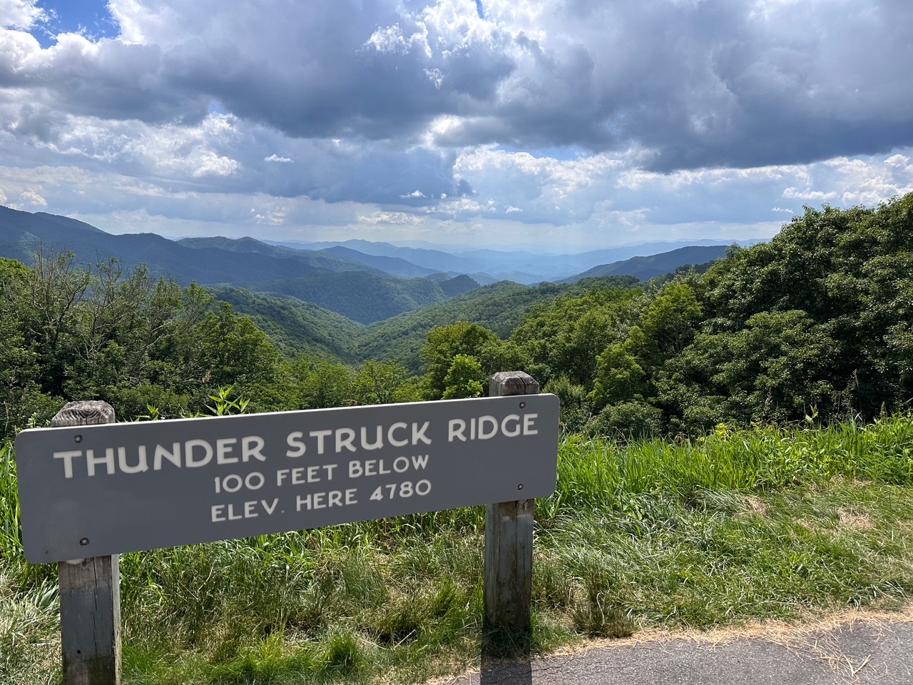
Thunder Struck Overlook
Thunder Struck Overlook (near Milepost 451 in the Waterrock Knob area) is a lesser-known pull-off that locals quietly appreciate.
The name reflects the dramatic weather patterns common at that elevation. Summer afternoons can build quickly into rolling mountain thunderstorms, and from this vantage point you can sometimes watch storm systems form and move across layered ridges.
It’s not heavily signed or commercialized — just a quiet overlook that captures the raw scale of the mountains. On clear days, the depth of the ridgelines is remarkable. On stormy ones, the name feels earned.
Are There Restaurants or Hotels on the Parkway?
Very few — and that’s intentional.
The Parkway was designed to avoid roadside commercialization.
You will not find:
- Gas stations
- Fast food
- Retail strips
In Western North Carolina, the primary lodging and dining directly on the Parkway is:
Pisgah Inn (MP 408.6)
- Seasonal lodging
- Full-service restaurant
- Country store (including snacks and ice cream)
- Outdoor deck seating
Most services require exiting the Parkway.
Can You Hunt on the Blue Ridge Parkway?
No.
The Parkway is federally managed National Park Service land, and hunting is prohibited within its boundaries.
It borders Pisgah National Forest in many places, where regulated hunting is allowed — but not within the Parkway corridor itself.
Campgrounds & Backcountry
The Parkway includes designated campgrounds, including:
- Mount Pisgah Campground (MP 408.8)
Dispersed roadside camping is not allowed.
Backcountry camping may require permits depending on the area.
Quick Facts
- 469 miles long
- Over 270 scenic overlooks
- Construction began in 1936
- Final section completed in 1987
- Highest point: Richland Balsam (6,053 feet)
- One of the most visited National Park Service units in the country
- Typical speed limit: 45 mph
- No billboards permitted
It was engineered to slow people down.
Why It Still Matters
The Blue Ridge Parkway preserved scenic ridgelines before modern development pressures intensified. It connected rural mountain communities to national tourism. It protected viewsheds that might otherwise have been lost.
Locals may casually say, “Let’s take the Parkway.”
But what they mean is:
Let’s climb above town.
Let’s slow down.
Let’s look out across something bigger.

Ready to Make Your Move in Western North Carolina?
We help buyers and sellers across Western North Carolina, including Haywood, Jackson, and Buncombe counties, move forward with clarity and confidence.
Jason Revelia
Call 828-342-1334 |
Email Jason
Shannon Revelia
Call 828-226-6767 |
Email Shannon


